
Page 112 - AERB
P. 112
7.4.6 Generation of Site-specific Data and Creation (Band 3 assigned as Red, Band 2 assigned as Green,
of Information System Band 1 assigned as Blue) (Fig. 7.12(a)) for Kakrapar
site has been created. The major land use categories are
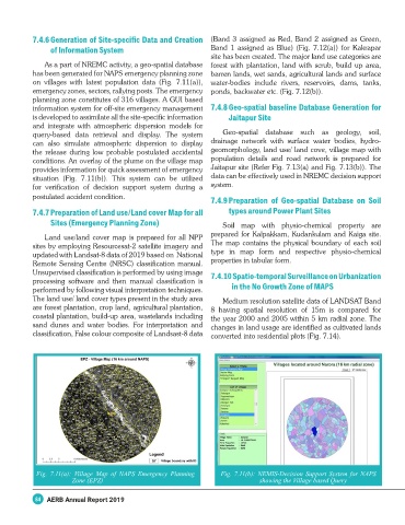
As a part of NREMC activity, a geo-spatial database forest with plantation, land with scrub, build up area,
has been generated for NAPS emergency planning zone barren lands, wet sands, agricultural lands and surface
on villages with latest population data (Fig. 7.11(a)), water-bodies include rivers, reservoirs, dams, tanks,
emergency zones, sectors, rallying posts. The emergency ponds, backwater etc. (Fig. 7.12(b)).
planning zone constitutes of 316 villages. A GUI based
information system for off-site emergency management 7.4.8 Geo-spatial baseline Database Generation for
is developed to assimilate all the site-specific information Jaitapur Site
and integrate with atmospheric dispersion models for
query-based data retrieval and display. The system Geo-spatial database such as geology, soil,
can also simulate atmospheric dispersion to display drainage network with surface water bodies, hydro-
the release during low probable postulated accidental geomorphology, land use/ land cove, village map with
conditions. An overlay of the plume on the village map population details and road network is prepared for
provides information for quick assessment of emergency Jaitapur site (Refer Fig. 7.13(a) and Fig. 7.13(b)). The
situation (Fig. 7.11(b)). This system can be utilized data can be effectively used in NREMC decision support
for verification of decision support system during a system.
postulated accident condition.
7.4.9 Preparation of Geo-spatial Database on Soil
7.4.7 Preparation of Land use/Land cover Map for all types around Power Plant Sites
Sites (Emergency Planning Zone) Soil map with physio-chemical property are
Land use/land cover map is prepared for all NPP prepared for Kalpakkam, Kudankulam and Kaiga site.
sites by employing Resourcesat-2 satellite imagery and The map contains the physical boundary of each soil
updated with Landsat-8 data of 2019 based on National type in map form and respective physio-chemical
Remote Sensing Centre (NRSC) classification manual. properties in tabular form.
Unsupervised classification is performed by using image 7.4.10 Spatio-temporal Surveillance on Urbanization
processing software and then manual classification is
performed by following visual interpretation techniques. in the No Growth Zone of MAPS
The land use/ land cover types present in the study area Medium resolution satellite data of LANDSAT Band
are forest plantation, crop land, agricultural plantation, 8 having spatial resolution of 15m is compared for
coastal plantation, build-up area, wastelands including the year 2000 and 2005 within 5 km radial zone. The
sand dunes and water bodies. For interpretation and changes in land usage are identified as cultivated lands
classification, False colour composite of Landsast-8 data converted into residential plots (Fig. 7.14).
Fig. 7.11(a): Village Map of NAPS Emergency Planning Fig. 7.11(b): NEMIS-Decision Support System for NAPS
Zone (EPZ) showing the Village based Query
84 AERB Annual Report 2019